Class-IX Social Science Geography Contemporary India -I Chapter 3: Drainage

1. Choose the right answer from the four alternatives given below.
i). In which of the following states is the Wular lake located?
a. Rajasthan
b. Uttar Pradesh
c. Punjab
d. Jammu and Kashmir
Ans. (d) Jammu and Kashmir
ii). The river Narmada has its source at
a. Satpura
b.  Brahmagiri
c. Amarkantak
d. Slopes of the Western Ghats
Ans. (c) Amarkantak
iii). Which one of the following lakes is a saltwater lake?
a. Sambhar

b.
Dal
c.
Wular
d.
Gobind Sagar
Ans. (a) Sambhar
iv). Which one of the following is the longest river of the Peninsular India?
a. Narmada
b. Krishna
c. Godavari
d. Mahanadi
Ans. (c) Godavari
v). Which one amongst the following rivers flows through a rift valley?
a. Mahanadi
b. Tungabhadra
c. Krishna
d. Tapi
Ans. (d) Tapi
2. Answer the following questions briefly.
i). What is meant by a water divide? Give an example.

Ans. A mountain range or a hill separating two different drainage basins is called a water divide. For example, Western Ghats.
ii). Which is the largest river basin in India?
Ans. The Ganga River basin is the largest river basin in India.
iii). Where do the rivers Indus and Ganga have their origin?
Ans. The Indus River has its origins in Tibet near the Mansarovar Lake while the Ganga River has its origins in the Gangotri Glacier in Uttarakhand state.
iv). Name the two headstreams of the Ganga. Where do they meet to form the Ganga?
Ans. Alaknanda and Bhagirathi are the two headstreams of the Ganga. They both meet to form the Ganga at Devprayag.
v). Why does the Brahmaputra in its Tibetan part have less silt, despite a longer course?
Ans. The Brahmaputra River, also known as Tsangpo in Tibet receives very little volume of water in Tibet, so it carries little silt there. But once it enters India from Arunachal Pradesh, it is fed by lots of rains and hence carries lots of water and silt.
vi). Which two Peninsular rivers flow through trough?
Ans. The two rivers that flow through troughs in India are Narmada and Tapi. They form estuaries while entering the sea unlike deltas.
vii). State some economic benefits of rivers and lakes.
Ans. Rivers are very beneficial for agricultural purposes and generating hydro- electricity. They also provide fisheries and inland channels for transportation. The lakes like the Sambhar Lake provide edible salts to people. They also help to develop tourism and provide recreation for people such as Panging Tso.

3. Below are given names of a few lakes of India. Group them into two categories – Natural and created by human beings.
a. Wular
b. Dal
c. Nainital
d. Bhimtal
e. Gobind Sagar
f. Loktak
g. Barapani
h. Chilika
h. Sambhar
i. Rana Pratap Sagar
j. Nizam Sagar
k. Pulicat
l. Nagarjuna Sagar
m. Hirakud
Ans. The Natural Lakes are: Wular, Dal, Nainital, Bhimtal, Chilika, Pulicat, Sambhar, Barapani, Loktak.

The Lakes created by human beings are Gobind Sagar, Hirakud, Rana Pratap Sagar, Nagarjuna Sagar, Nizam Sagar.
4. Discuss the significant difference between the Himalayan and the Peninsular rivers.
Ans. The following is the comparison of the two rivers:

Sl. No.
Himalaya Rivers
Peninsular Rivers
1
Himalayan rivers are perennial.
Peninsular rivers are seasonal.
2
They are fed by glaciers.
They receive water from the rainfall.
3
The Himalayan rivers are long and deep.
The peninsular rivers are short and shallow.
4
They carry a lot silt and sand.
They carry very no silt.
5
These rivers originate in the Himalayas in northern India.
These rivers originate in the Western Ghats.
6
Their drainage basins are large.
Their drainage basins are small.
7
These rivers form very large deltas.
They form very small or no deltas.

5. Compare the east flowing and the west flowing rivers of the Peninsular plateau.
Ans. The following is the comparison of the two rivers:

Sl. No.
East Flowing Rivers
West Flowing Rivers
1
They fall into the Bay of Bengal.
They fall into the Arabian Sea.
2
They form Estuaries
They form Deltas.
3
They have a large tributary network.
They have no tributary networks.
4
They do not flow through troughs.
They flow through troughs.

6. Why are rivers important for the country’s economy?
Ans. The rivers important for the any country’s economy because:
• They are a source of natural fresh water which is required for the survival of all living beings.
• The rivers provide water for various purposes as well as act as important trade routes within the country.
• They also serve as a source of potential energy using hydro power.
• It is also used for navigation and transportation and is important for commercial activities.

• It also provides great scenic and recreational values for tourism. Thus, they serve as good tourist spots in the state.
(i) On an outline map of India mark and label the following rivers: Ganga, Satluj, Damodar, Krishna, Narmada, Tapi, Mahanadi, and Brahmaputra.
(ii) On an outline map of India mark and label the following lakes: Chilika Sambhar, Wular, Pulicat, Kolleru.

Ans:

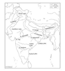
Outline Map of India mark Lakes

Study materials

Send Us A Message

Latest posts

Scroll to Top

REGISTER NOW

👉 (Limited Seats Available) 👈

Thank You For Registering !

Our Team Will Reach You Soon