4. Which are the major physiographic divisions of India? Contrast the relief of the Himalayan region with that of the Peninsular plateau.
Ans: The major physiographic divisions of India are:
• The Himalayan Mountains
• The Northern Plains
• The Peninsular Plateau
• The Indian Desert
• The Coastal Plains
• The Islands
5. Give an account of the Northern Plains of India.
Ans: The Northern Plains are formed by the deposition of the fertile alluvium that was deposited by the rivers originating in the Himalayas. They stretch from the south of the northern mountains to the north of the peninsular plateau and towards the east of the Indian desert. It is divided into three parts, i.e. Punjab Plains, Ganga Plains and the Brahmaputra Plains. The Northern plains cover approximately 3000 kilometers and there are several rivers that drain this region such as Sutlej, Ravi, Beas, Ganga, Yamuna, Ghagra, Gandak, Kosi, Chambal, Betwa, Son, etc.
The North Indian Plains are divided into four different zones:
1. Bhabhar
2. Tarai
3. Bangar
4. Khadar
6. Write short notes on the following.
(i). The Indian Desert
Ans: The Great Indian Desert is also known as the Thar Desert and is located in Rajasthan, India and also in Punjab and Sindh in Pakistan. A part of the desert is also located in the states of Gujarat and Haryana.
The Thar desert is a very dry region in between the countries of India and Pakistan and is highly scarce in water availability and the only water sources are the natural and man-made ponds across the region. Due to this reason, the people generally live a nomadic life, which involves their constant movement from place to place. The Luni River is an important river in the Thar desert, and it drains a large area of the desert. The other major river is Ghaggar which flows in the northern and eastern part of the desert.
(ii). The Central Highlands
Ans: The parts of the peninsular plateau which are found in the north of the River Narmada and generally covers a major portion of the Malwa plateau is known as the Central Highlands. The rivers which drain this region flow from southwest to northeast, due to their slope. The Central Highlands are wider in the western side but narrow down towards the east. In Madhya Pradesh, Uttar Pradesh and Chhattisgarh, they are known as Bundelkhand and Baghelkhad. The Chotanagpur plateau is in the extreme east of the Central Highlands with the the Damodar River flowing through it.
(iii). The Island groups of India
Ans: There are two island groups controlled by India. They are located in the Arabian Sea (Lakshadweep Islands) and the Bay of Bengal (Andaman and Nicobar Islands). These islands are located off the Malabar coast of India. The capital city of Lakshadweep Islands is Kavaratti and is the smallest Union territory by area and the second smallest by population. The Islands of Lakshadweep provide India a strategic base in the Arabian Sea and India is able to reach out to the Maldives and other regions in the Indian Ocean in crucial times.
The Andaman and Nicobar Islands are a group of 572 islands. The Nicobar Islands extend close to the Sumatra islands which make the reach of India to Southeast Asian nations very easy, The Indian Navy also maintains a base in the Andaman and Nicobar Islands which helps it to control the vessels passing through the strait of Malacca. The Andaman and Nicobar Islands also have the North Sentinel Island which has the most primitive people from the human race and are untouched by civilization and they are known as the Sentinelese people.
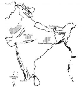
Map Skills:
On an outline map of India show the following.
(i). Mountain and hill ranges – the Karakoram, the Zaskar, the Patkai Bum, the Jaintia, the Vindhya range, the Aravali, and the Cardamom hills.
(ii). Peaks – K2, Kanchenjunga, Nanga Parbat and the Anai Mudi.
(iii). Plateaus, Chotanagpur and Malwa
(iv). The Indian Desert, Western Ghats, Lakshadweep Islands
Ans: